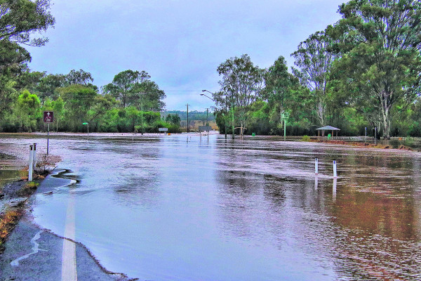
FLOOD rains began on Wednesday May 11 and generated falls of up to 250 millimetres onto already saturated paddocks, dams and creeks within the region.
Flood preparations began almost immediately due to the Bureau of Meteorology predictions of days of rain and for some residents, memories resurfaced of the devastation caused by the 1974 flood.
Wayne Lund, who now lives in Ipswich, said he was on the edge of his seat as he kept an eye on reports in Grandchester, the place where he grew up and witnessed the 1974 flood when he was 10 years of age.
“Just one more downpour or a storm would have pushed the already flood inundated bridges and creeks over the edge, it would have been just like the 1974 flood that I remember just like it was yesterday,” he said.
“It is a memory that will last with me for a life time … an event that was marked as a once in a lifetime event, and this recent flood brought it all back to me.
In 1974, Wayne’s family lived on a farm at Grandchester.
“The rain fell for days; paddocks were swamped, dams were spilling, bridges were inundated and some of the roads were unrecognisable.
“All of the fences on our farm were swept away.
“People were in shock by what was happening around them and the deluge after the flood waters receded was too much for families who were left picking up the pieces for months.”
Wayne remembers the rain as relentless, though it was a storm that struck the region after weeks of rain that Wayne said pushed the water levels higher and higher, the only thing that was different to the recent flood event.
“Witnessing all of the photos and reports on what was happening in Grandchester, was exactly as it was in 1974, the only difference is we were lucky enough not to see a storm follow the days of rain,” he said.
“It would have been a disaster, if a storm came through.
“I feel sorry for the families who have been affected by the flood waters and for the businesses that have already suffered so much.”
Wayne was not the only one to reflect on recent floods.
Byron Hall has lived with his family in Rosewood for 30 years and he said that this year has been the wettest year he could remember.
“I was not living in Queensland in 1974, however after moving to Rosewood in 1992, I was working for the Brisbane City Council during the 2011 floods which I recall as being horrific,” he said.
“I was unable to get home for three days, though since then there has been some flood mitigation in Rosewood which has helped stop the main street from flooding.”
The Rosewood Detention Basin was built by the Ipswich City Council in 2002 to hold back overland flow. It was upgraded in 2016 by increasing the height of the embankment to 5.5 metres. On Thursday afternoon last week, the water height reached 0.85 metres.
“This recent flood is similar to that of 2011 because Rosewood simply gets cut off. Our local roads are not designed to handle so much water,” he said.
“Flooding prevents us from being able to visit our children and grandchildren who do not live in Rosewood, it also restricts essential supplies from getting into town.
“The Seven Mile Bridge on the Bremer River, the road to Ebenezer, Lanefield and Walloon still floods significantly, stopping families from leaving the area.”
By Friday afternoon last week, floodwaters had cut the Ipswich Rosewood Road, Rosewood Warrill View Road, Rosewood Laidley Road, Karrabin Rosewood Road and Haigslea Amberley Road leaving limited options for families who needed to travel out of Rosewood.
While the rain eased on Friday afternoon, as a precaution a place of refuge was opened at Rosewood State High school. It closed at 11pm the same night.